
If you own real estate, do you know where your property line is? Do your neighbors agree with the boundary between you and them? Are you sure? Maybe this article can shed some light on any questions you might have about property line delineation.
From mid-2016 to early-2018, this author worked at the County Assessor’s Office as a G.I.S. Property Specialist for the largest county in Arizona. My duties required me to research title histories and make absolute determination of property boundaries and ownership. This research was used to prove exact property boundaries and property ownership. Some of the relevant records found in this research dated to the late 1800’s. Reading cursive hand-writing on microfiche copies of transfers of title for real property that sometimes mention consideration (payment) in the form of chickens and livestock was always an entertaining highlight to work that is very boring and clerical.
County Assessors are the government entity typically charged with the responsibility of recording real property ownership of private and public entities, and the boundaries between properties. This record is more than just a map, it is also a record of who owns which property. The Cadastre, (effectively a database) as this record is called, is a comprehensive legal register of real estate and real property ownership and is considered as the definitive arbiter of most all boundary disputes. Public rights-of-way are another major portion of real property that a County Cadastre delineates.
https://www.heavy.ai/technical-glossary/cadastral
Before I go any further … I am offering no paid services here, nor am I offering any legal advice.
If you are a property owner, I’d like to exhort you right now to take proactive measures with your title, and especially the property descriptions that define your property boundaries.

Know your property boundaries to the 1/4 inch, or better. I highly recommend finding the local surveyor in your county who has the most experience with property boundaries and especially in writing good descriptions that can be reproduced for decades to come. He can set iron stakes at your property corners that you will have certainty are where they are supposed to be. Just use a competent surveyor, for your own peace of mind. For the sake of legal arguments to be avoided in the future, do not rely on an app or anything other than a registered surveyor when determining your property lines.
What I mean is, most surveyors know not to use a tree or a rock for a Point of Beginning, as a crude example. A good cadastral surveyor will know how to “tie-in” his descriptions to already established adjacent properties and known control points. He will do the research needed to find the appropriate property descriptions for ALL the adjacent properties to yours.
He will also know how to write property descriptions that will be easy to recreate, possibly with a bit of redundancy (secondary measurements and or control points) included in the boundary description, just for good measure. (Sorry, THAT pun -was- intentional. I regret nothing.)
There are two types of systems used for describing real estate boundaries:
The first of these systems is known as PLSS – Public Land Survey System, a rectangular grid system, based on arbitrarly lines (baselines), and divided into Township and Range sub-grids, is used by the vast majority of states in the U.S. for real estate property boundary descriptions. This is the system that creates “sections” of land, i.e. 640 acres.
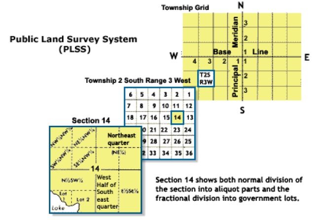
https://www.gislounge.com/what-is-the-public-land-survey-and-why-do-we-still-use-it/
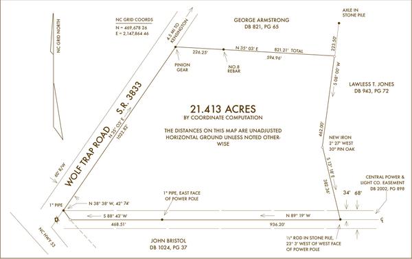
The second system is known as Metes & Bounds – based on items in nature that are (mostly) permanent, like a river bend or an old oak tree… where ol’ whats-his-name was hanged in 19-aught-9.
Metes and Bounds Definition
A metes and bounds description can be lengthy, confusing, and daunting to a novice who may not know how to read and interpret its narrative. The description defines the lands from the point of beginning (a property corner) around the entirety of the parcel, typically in a clockwise fashion, back to the point of beginning. Each line or course is described by two components, the “metes” and the “bounds.”
- The metes is the math of the described property lines that circumscribes the perimeter of the parcel.
- The bounds are cited to state what each line is bounded by.
Metes and Bounds Example
An example of a defined property line by metes and bounds would be “ {Ooze’s note: this description is missing a Point Of Beginning, therefore, rendering it invalid! Property boundary descriptions MUST be absolutely correct to be legal!} Thence North 89 degrees, 39 minutes, 47 seconds West, a distance of 147.33 feet (the metes), along the southerly line of property now or formerly owned by John Smith (the bounds).”
The math, or the metes, contains three parts to define the line:
- A directional call
- An angle described in degrees, minutes, and seconds
- A distance typically cited in feet and tenths of a foot
In the above example, the directional call is North/West. The angle is 89 degrees, 39 minutes, 47 seconds (also delineated as 89° 39’ 47”) and the distance is 147.33’ (or feet). When calculated, observed, and reconciled by the surveyor, the metes should form a mathematically closed figure.
All state statutes for the practice of land surveying include precision requirements with very stringent tolerances for closure.
Despite the potentially daunting exercise of translating arcane gibberish into a valid and useful map of a property boundary can actually be pretty simple. If you are lucky, your county assessor has created a “Parcel Viewer” that will enable you to extract important property information by using a color map with aerial imagery.
Maricopa County, Arizona, the home of Phoenix, has an excellent “parcel viewer” interface for their Maricopa County Assessor department. It really is one of the best in the nation. Just for reference, Maricopa County is roughly the same size as Harris County, Texas, home of Houston.
https://maps.mcassessor.maricopa.gov/
Are there potential pitfalls to taking an active interest in properly delineating your real estate property lines? That’s hard to say. Mostly, expect to find inconsistencies that have been propagated from one title agency to another as the property has been conveyed from one party to the next over the years. “Cut and Paste” is not your friend in this realm of real estate.
There are plenty of online references that provide definitions, concepts, examples and anecdotal accounts of the pitfalls of the various title types and transfer methods. Below is a link that looked good to me with just the few dozen seconds of perusal I had time to give it. There are some important concepts on the following website that would require too much time to elaborate upon in this article.
https://www.upcounsel.com/lectl-property-boundaries
There are so many intricacies to titles and property boundaries that I couldn’t hope to give those topics the time and energy they deserve. Suffice to say, property boundaries and titles for real estate and real property do not have to be so technical as to be impossible to understand.
If your county isn’t as digital-friendly as Maricopa County is, you may need to go old-school and head down to the County Courthouse, or whichever government entity hols such records, like a County Recorder.
https://www.waldeneffect.org/blog/How_to_do_a_property_title_search/
https://www.waldeneffect.org/blog/How_to_map_property_boundaries_from_a_deed/
Title Lock deserves your diligent research. I don’t have any expertise on “Title Lock” at all. My expertise is 1) determining clear title, and 2) accurately mapping property boundaries from published property descriptions. The mapping part is referred to as Cadastral Mapping.
https://www.heavy.ai/technical-glossary/cadastral
Property descriptions written by surveyors can be a huge source of trouble for future transfers or simple fence construction. Know your property boundaries at risk of losing your real property. It happens all the time. A neighbor builds a fence that isn’t on his real property. An easement is the usual compromise, since the fence is already built. Save yourself future potential aggravation by being proactive in delineating your real estate property boundaries. Don’t let your property be held in limbo by a bureaucrat in some future time who is “just doing his job” by holding up a title transfer due to irregularities. It’s YOUR property! It’s up to YOU to hold it.
I’ll do my best to answer any questions on this subject that I’m qualified to answer. Bear with me, though. I’m in the middle of a major relocation effort.